
Breezeway Bay topographic map
Click on the map to display elevation.
About this map
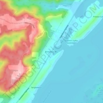
Name: Breezeway Bay topographic map, elevation, terrain.
Location: Breezeway Bay, Marshall County, Alabama, United States (34.48509 -86.20887 34.52509 -86.16887)
Average elevation: 764 ft
Minimum elevation: 581 ft
Maximum elevation: 1,230 ft
Marshall County trails, hiking, mountain biking, running and outdoor activities
Other topographic maps
Click on a map to view its topography, its elevation and its terrain.
Arab
United States > Alabama > Marshall County
Arab is located at an elevation of 1,100 feet (340 m) on top of Brindlee Mountain, near the southwest end of the Appalachian Plateau. The city is primarily in southern Marshall County; a small portion extends south into Cullman County. U.S. Route 231 runs north-to-south through Arab, and State Route 69 runs…
Average elevation: 1,030 ft
Union Grove
United States > Alabama > Marshall County
Union Grove is located in western Marshall County at 34°24′0″N 86°26′46″W / 34.40000°N 86.44611°W / 34.40000; -86.44611 (34.400088, -86.446049). It is 7 miles (11 km) northeast of Arab and 5 miles (8 km) southwest of Guntersville Dam on the Tennessee River. Union Grove sits at an elevation…
Average elevation: 997 ft
Grant
United States > Alabama > Marshall County
Grant is located in northeastern Marshall County at an elevation of 1,240 feet (380 m) on the plateau of Gunters Mountain. The town is concentrated along County Road 5 (Cathedral Caverns Highway, signed as Main Street in Grant) near the northern edge of Gunters Mountain, though the town includes corridors…
Average elevation: 984 ft
Albertville
United States > Alabama > Marshall County
According to the U.S. Census Bureau, Albertville has a total area of 27.0 square miles (69.9 km2), of which 0.1 square miles (0.3 km2), or 0.37%, are water. The city sits at an elevation of 1,060 feet (320 m) atop Sand Mountain, a plateau that in this area is about 15 miles (24 km) wide. The Tennessee Valley…
Average elevation: 1,014 ft
Arab
United States > Alabama > Marshall County
Arab is located at an elevation of 1,100 feet (340 m) on top of Brindlee Mountain, near the southwest end of the Appalachian Plateau. The city is primarily in southern Marshall County; a small portion extends south into Cullman County. U.S. Route 231 runs north-to-south through Arab, and State Route 69 runs…
Average elevation: 1,030 ft
Albertville
United States > Alabama > Marshall County
The city sits at an elevation of 1,060 feet (320 m) atop Sand Mountain, a plateau that in this area is about 15 miles (24 km) wide. The Tennessee Valley Divide passes through the southern part of the city. The majority of the city drains north to Short Creek, a tributary of the Tennessee River, while the…
Average elevation: 1,014 ft