
Make a donation
Gear up for your next adventure:
As an Amazon Associate, this site earns from qualifying purchases at no extra cost to you.
Bellwood topographic map
Click on the map to display elevation.
Make a donation
Gear up for your next adventure:
As an Amazon Associate, this site earns from qualifying purchases at no extra cost to you.
About this map
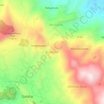
Name: Bellwood topographic map, elevation, terrain.
Location: Bellwood, Kandy District, Central Province, 20420, Sri Lanka (7.19484 80.65950 7.23484 80.69950)
Average elevation: 2,969 ft
Minimum elevation: 1,749 ft
Maximum elevation: 4,278 ft
Make a donation
Gear up for your next adventure:
As an Amazon Associate, this site earns from qualifying purchases at no extra cost to you.
Other topographic maps
Click on a map to view its topography, its elevation and its terrain.
Make a donation
Gear up for your next adventure:
As an Amazon Associate, this site earns from qualifying purchases at no extra cost to you.
upper division, north meddecombra
Sri Lanka > Central Province > upper division, north meddecombra
Average elevation: 4,160 ft