
Make a donation
Gear up for your next adventure:
As an Amazon Associate, this site earns from qualifying purchases at no extra cost to you.
Pico Balaitús topographic map
Click on the map to display elevation.
Make a donation
Gear up for your next adventure:
As an Amazon Associate, this site earns from qualifying purchases at no extra cost to you.
Pico Balaitús
Hoy en día hay muchas rutas para escalar, pero ninguna de ellas es realmente fácil, especialmente por la diferencia de altitud, que es de más de 1500 m desde cualquier punto accesible en coche. Las rutas más populares están a lo largo del glaciar Las Neo. Algunas rutas, que conducen a la cumbre desde el lado español, toman la diagonal característica del Balaitús. Los refugios franceses de Larribet (2060 m), Balaïtous (G. Ledormeur) (1970 m) o Arrémoulit (2305 m) son posibles puntos de partida. En el lado español se puede usar el refugio de Respomuso.
Make a donation
Gear up for your next adventure:
As an Amazon Associate, this site earns from qualifying purchases at no extra cost to you.
About this map
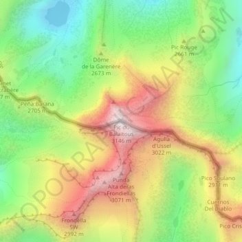
Name: Pico Balaitús topographic map, elevation, terrain.
Average elevation: 8,543 ft
Minimum elevation: 7,152 ft
Maximum elevation: 10,226 ft
Make a donation
Gear up for your next adventure:
As an Amazon Associate, this site earns from qualifying purchases at no extra cost to you.
Other topographic maps
Click on a map to view its topography, its elevation and its terrain.