Geolocate

Montchavin topographic map

Click on the map to display elevation.

About this map

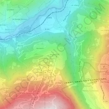
Name: Montchavin topographic map, elevation, terrain.

Location: Montchavin, Bellentre, La Plagne-Tarentaise, Albertville, Savoy, Auvergne-Rhône-Alpes, Metropolitan France, 73210, France (45.53989 6.71656 45.57989 6.75656)

Average elevation: 3,924 ft

Minimum elevation: 2,333 ft

Maximum elevation: 6,473 ft

Other topographic maps

Click on a map to view its topography, its elevation and its terrain.

73210

France > Auvergne-Rhône-Alpes > Savoy > La Plagne-Tarentaise > Sangot

Average elevation: 5,794 ft

Gear up for your next adventure:

👟Trail Running Shoes - Lightweight shoes for trail runners
🔦LED Headlamp - Bright and durable LED headlamp for night navigation
🦶Hiking Gaiters - Keep debris and water out of your boots
🔪Outdoor Multitools - Essential survival tools for gear repair and field use
📖Nature Tracking Books - Learn to track wildlife and terrain

As an Amazon Associate, this site earns from qualifying purchases at no extra cost to you.