
Thank you for supporting this site ❤️
Make a donation
Make a donation
Gear up for your next adventure:
As an Amazon Associate, this site earns from qualifying purchases at no extra cost to you.
Maniis topographic map
Click on the map to display elevation.
Thank you for supporting this site ❤️
Make a donation
Make a donation
Gear up for your next adventure:
As an Amazon Associate, this site earns from qualifying purchases at no extra cost to you.
About this map
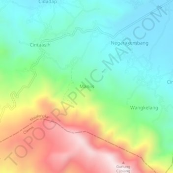
Name: Maniis topographic map, elevation, terrain.
Location: Maniis, Majalengka, West Java, Java, Indonesia (-7.06909 108.30482 -7.02909 108.34482)
Average elevation: 2,815 ft
Minimum elevation: 1,903 ft
Maximum elevation: 4,501 ft
Thank you for supporting this site ❤️
Make a donation
Make a donation
Gear up for your next adventure:
As an Amazon Associate, this site earns from qualifying purchases at no extra cost to you.