
Ellijay topographic map
Click on the map to display elevation.
Ellijay
Ellijay sits within a rugged and mountainous terrain, characterized by rolling hills, deep valleys, and ridgelines that are part of the larger Appalachian Mountain system. The area has an average elevation of about 1,390 feet, though nearby peaks like Walnut Mountain rise to elevations over 2,500 feet. The landscape is shaped by a series of steep ridges and creeks, with significant features such as the Cartecay and Ellijay Rivers weaving through the valleys. The region's topography provides stunning vistas and is ideal for outdoor activities like hiking and river rafting, with the mountains offering both a natural barrier and a unique ecological environment. This combination of elevation and terrain makes Ellijay a prime destination for nature lovers and adventure seekers.
About this map
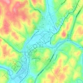
Name: Ellijay topographic map, elevation, terrain.
Location: Ellijay, Gilmer County, Georgia, 30540, United States (34.66807 -84.51152 34.70778 -84.46965)
Average elevation: 1,391 ft
Minimum elevation: 1,224 ft
Maximum elevation: 1,627 ft
Gilmer County trails, hiking, mountain biking, running and outdoor activities
Other topographic maps
Click on a map to view its topography, its elevation and its terrain.