
Playa De Penarronda topographic map
Interactive map
Click on the map to display elevation.
About this map
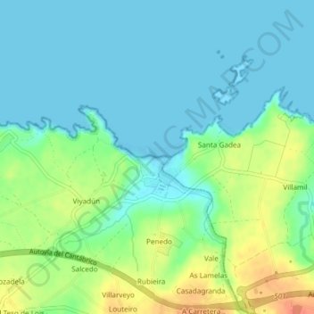
Name: Playa De Penarronda topographic map, elevation, terrain.
Location: Playa De Penarronda, CP-2, Castropol, Asturias, 33794, España (43.55167 -7.00122 43.55489 -6.99241)
Average elevation: 46 ft
Minimum elevation: 0 ft
Maximum elevation: 151 ft
Other topographic maps
Click on a map to view its topography, its elevation and its terrain.