
Make a donation
Gear up for your next adventure:
As an Amazon Associate, this site earns from qualifying purchases at no extra cost to you.
Kwoor topographic map
Click on the map to display elevation.
Make a donation
Gear up for your next adventure:
As an Amazon Associate, this site earns from qualifying purchases at no extra cost to you.
Kwoor
Koor is located on the western side of the mouth of the Koor River. The Koor River flows down from the Tosem-Koor Mountains, a rugged massif which has a maximum elevation of around 1700 metres. A sand spit lies at the mouth of the river, to the northeast of the village. Several of the village buildings are located on the sandy beach and others are located further inland under the protection of vegetation. Geologically the village lies on a part of Irian Jaya called the Koor Fault. The villagers speak a language known as the Abun language, common to this coastline.
Make a donation
Gear up for your next adventure:
As an Amazon Associate, this site earns from qualifying purchases at no extra cost to you.
About this map
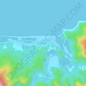
Name: Kwoor topographic map, elevation, terrain.
Average elevation: 144 ft
Minimum elevation: -20 ft
Maximum elevation: 1,276 ft
Make a donation
Gear up for your next adventure:
As an Amazon Associate, this site earns from qualifying purchases at no extra cost to you.
Other topographic maps
Click on a map to view its topography, its elevation and its terrain.