
Brackley Beach topographic map
Interactive map
Click on the map to display elevation.
About this map
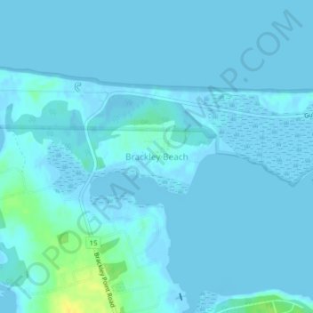
Name: Brackley Beach topographic map, elevation, terrain.
Average elevation: 7 ft
Minimum elevation: -10 ft
Maximum elevation: 72 ft
Other topographic maps
Click on a map to view its topography, its elevation and its terrain.
Charlottetown
Canada > Prince Edward Island > Charlottetown
Charlottetown, Queens County, Prince Edward Island, C1A 1R4, Canada
Average elevation: 69 ft
Grand Tracadie
Canada > Prince Edward Island > Charlottetown > Grand Tracadie
Grand Tracadie, Charlottetown, Queens County, Prince Edward Island, Canada
Average elevation: 23 ft