Geolocate

Precicchie topographic map

Click on the map to display elevation.

About this map

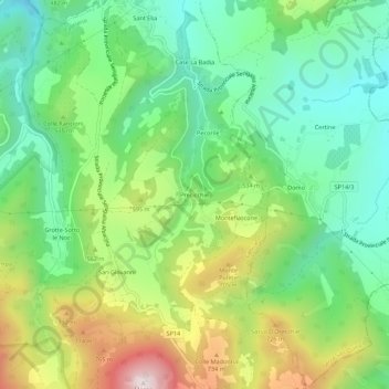
Name: Precicchie topographic map, elevation, terrain.

Location: Precicchie, Fabriano, Ancona, Italy (43.38090 13.02642 43.42090 13.06642)

Average elevation: 1,617 ft

Minimum elevation: 751 ft

Maximum elevation: 3,205 ft

Gear up for your next adventure:

🧯Portable Fire Pit - Compact fire pit for camping spots
🧦Merino Wool Socks - Moisture-wicking, blister-preventing socks for long treks
🧭Outdoor Navigation Book - Learn advanced navigation skills
👟Trail Running Shoes - Lightweight shoes for trail runners
📚Navigation Handbooks - Master the art of reading topographic maps and using a compass

As an Amazon Associate, this site earns from qualifying purchases at no extra cost to you.