Geolocate

Gorham topographic map

Click on the map to display elevation.

About this map

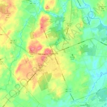
Name: Gorham topographic map, elevation, terrain.

Location: Gorham, Cumberland County, Maine, 04038, USA (43.63969 -70.48293 43.71969 -70.40293)

Average elevation: 167 ft

Minimum elevation: 59 ft

Maximum elevation: 328 ft

Gear up for your next adventure:

🌡️Handheld Weather Meters - Measure wind, temp, and pressure for safe mountain travel
🏕️Tent Footprint - Protect your tent base from wear
🧣Merino Neck Gaiters - Multi-functional headwear for wind and sun protection
🦺Reflective Outdoor Gear - Safety gear for low‑light conditions
🔭Telescopic Hiking Pole - Adjustable pole for hiking stability

As an Amazon Associate, this site earns from qualifying purchases at no extra cost to you.