Geolocate

Butts topographic map

Click on the map to display elevation.

About this map

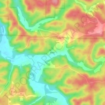
Name: Butts topographic map, elevation, terrain.

Location: Butts, Crawford County, Missouri, United States (37.97588 -91.17625 38.01588 -91.13625)

Average elevation: 830 ft

Minimum elevation: 656 ft

Maximum elevation: 1,001 ft

Crawford County trails, hiking, mountain biking, running and outdoor activities

Other topographic maps

Click on a map to view its topography, its elevation and its terrain.

Cuba

United States > Missouri > Crawford County

Average elevation: 994 ft

West Sullivan

United States > Missouri > Crawford County

Average elevation: 971 ft

Steelville

United States > Missouri > Crawford County

Average elevation: 840 ft

Gear up for your next adventure:

🧯Portable Fire Pit - Compact fire pit for camping spots
🥘Titanium Cookware - Durable, featherlight pots and pans for backpacking
🧦Merino Wool Socks - Moisture-wicking, blister-preventing socks for long treks
📌Outdoor GPS Map App - Apps and devices for digital topographic navigation
🌲Outdoor Survival Books - Best books on survival skills

As an Amazon Associate, this site earns from qualifying purchases at no extra cost to you.