Geolocate

Wingham topographic map

Click on the map to display elevation.

About this map

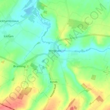
Name: Wingham topographic map, elevation, terrain.

Location: Wingham, Dover, Kent, England, United Kingdom (51.24780 1.19261 51.29379 1.24494)

Average elevation: 72 ft

Minimum elevation: 0 ft

Maximum elevation: 200 ft

Other topographic maps

Click on a map to view its topography, its elevation and its terrain.

Beech Grove Bruderhof

United Kingdom > England > Kent > Dover > Nonington

Average elevation: 177 ft

Elmstone

United Kingdom > England > Kent > Dover > Preston

Average elevation: 43 ft

Sandwich Bay

United Kingdom > England > Kent > Dover

Average elevation: 3 ft

Claypits

United Kingdom > England > Kent > Dover > Goodnestone

Average elevation: 112 ft

Richborough

United Kingdom > England > Kent > Dover

Average elevation: 13 ft

Gear up for your next adventure:

🧯Emergency Survival Kit - All‑in‑one survival essentials for the backcountry
🗻Climbing Gear Basics - Essential gear for beginner climbers
🧭GPS Watch Accessories - Bands and chargers for GPS watches
🪓Survival Multi‑Tool - Versatile tool for camp and trail tasks
🔭Stargazing Telescopes - Perfect for camping in low-light pollution areas shown on maps

As an Amazon Associate, this site earns from qualifying purchases at no extra cost to you.