
Make a donation
Gear up for your next adventure:
As an Amazon Associate, this site earns from qualifying purchases at no extra cost to you.
Cullen topographic map
Click on the map to display elevation.
Make a donation
Gear up for your next adventure:
As an Amazon Associate, this site earns from qualifying purchases at no extra cost to you.
About this map
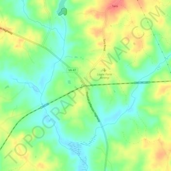
Name: Cullen topographic map, elevation, terrain.
Location: Cullen, Charlotte County, Virginia, 23934, United States (37.09765 -78.66917 37.13765 -78.62917)
Average elevation: 495 ft
Minimum elevation: 407 ft
Maximum elevation: 620 ft
Charlotte County trails, hiking, mountain biking, running and outdoor activities
Make a donation
Gear up for your next adventure:
As an Amazon Associate, this site earns from qualifying purchases at no extra cost to you.
Other topographic maps
Click on a map to view its topography, its elevation and its terrain.
Staunton River State Park
United States > Virginia > Charlotte County > Laconia
Average elevation: 361 ft