Geolocate

Lecco topographic map

Click on the map to display elevation.

About this map

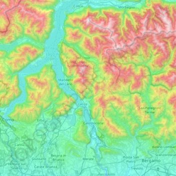
Name: Lecco topographic map, elevation, terrain.

Location: Lecco, Lombardy, Italy (45.64938 9.24373 46.15172 9.54111)

Average elevation: 2,615 ft

Minimum elevation: 502 ft

Maximum elevation: 8,366 ft

Other topographic maps

Click on a map to view its topography, its elevation and its terrain.

Albese

Italy > Lombardy > Como > Albese con Cassano

Average elevation: 1,578 ft

Serta

Italy > Lombardy > Bergamo > Schilpario

Average elevation: 4,678 ft

Monteacuto

Italy > Lombardy > Brescia > Palude

Average elevation: 650 ft

Salice Terme

Italy > Lombardy > Pavia > Godiasco Salice Terme

Average elevation: 725 ft

Prestine

Italy > Lombardy > Brescia

Average elevation: 2,559 ft

Faggeto Beach

Italy > Lombardy > Como > Faggeto Lario > Molina > Riva

Average elevation: 1,191 ft

Agro

Italy > Lombardy > Bergamo

Average elevation: 3,031 ft

Gear up for your next adventure:

🧷Carabiner Set - Durable clips for gear attachment
🥘Titanium Cookware - Durable, featherlight pots and pans for backpacking
💧Water Purification System - Clean water on the trail with reliable purifiers
🧭Orienteering Set - Complete compass and map reading kit
📷Action Cameras - Rugged cameras to document your journeys across rugged terrain

As an Amazon Associate, this site earns from qualifying purchases at no extra cost to you.