
Make a donation
Gear up for your next adventure:
As an Amazon Associate, this site earns from qualifying purchases at no extra cost to you.
Ludmannsdorf topographic map
Click on the map to display elevation.
Make a donation
Gear up for your next adventure:
As an Amazon Associate, this site earns from qualifying purchases at no extra cost to you.
Ludmannsdorf
Das Gemeindegebiet von Ludmannsdorf erstreckt sich nördlich der Drau und südlich des Wörthersees zwischen den Gemeinden Velden am Wörther See und Köttmannsdorf. Es liegt auf dem stark bewaldeten Höhenzug der Sattnitz, einer Endmoräne der Eiszeit, und überblickt das Rosental und die Karawanken. Die Seehöhe des Gemeindegebiets liegt zwischen 600 und 900 Meter.
Make a donation
Gear up for your next adventure:
As an Amazon Associate, this site earns from qualifying purchases at no extra cost to you.
About this map
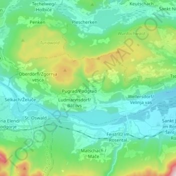
Name: Ludmannsdorf topographic map, elevation, terrain.
Average elevation: 2,070 ft
Minimum elevation: 1,394 ft
Maximum elevation: 4,367 ft
Make a donation
Gear up for your next adventure:
As an Amazon Associate, this site earns from qualifying purchases at no extra cost to you.
Other topographic maps
Click on a map to view its topography, its elevation and its terrain.
Ebenthal in Kärnten
Österreich > Kärnten > Bezirk Klagenfurt-Land > Ebenthal in Kärnten
Average elevation: 1,637 ft
Make a donation
Gear up for your next adventure:
As an Amazon Associate, this site earns from qualifying purchases at no extra cost to you.
Hinterberg
Österreich > Kärnten > Bezirk Klagenfurt-Land > Ebenthal in Kärnten > Obitschach
Average elevation: 1,946 ft
Make a donation
Gear up for your next adventure:
As an Amazon Associate, this site earns from qualifying purchases at no extra cost to you.
Make a donation
Gear up for your next adventure:
As an Amazon Associate, this site earns from qualifying purchases at no extra cost to you.
Klagenfurt Land
Österreich > Kärnten > Bezirk Klagenfurt-Land > Krumpendorf am Wörthersee
Average elevation: 2,933 ft
Sapotnica
Österreich > Kärnten > Bezirk Klagenfurt-Land > Ferlach > Sapotnica
Average elevation: 3,333 ft
Make a donation
Gear up for your next adventure:
As an Amazon Associate, this site earns from qualifying purchases at no extra cost to you.