
Make a donation
Gear up for your next adventure:
As an Amazon Associate, this site earns from qualifying purchases at no extra cost to you.
Rocourt topographic map
Click on the map to display elevation.
Make a donation
Gear up for your next adventure:
As an Amazon Associate, this site earns from qualifying purchases at no extra cost to you.
About this map
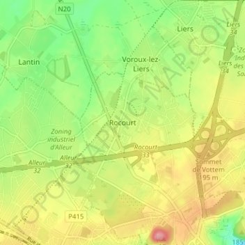
Name: Rocourt topographic map, elevation, terrain.
Location: Rocourt, Liège, Wallonie, 4000, Belgique (50.65804 5.52762 50.69804 5.56762)
Average elevation: 568 ft
Minimum elevation: 407 ft
Maximum elevation: 745 ft
Make a donation
Gear up for your next adventure:
As an Amazon Associate, this site earns from qualifying purchases at no extra cost to you.
Other topographic maps
Click on a map to view its topography, its elevation and its terrain.
Val-Benoît
Belgique > Liège > Liège > Liège
Après la Première Guerre mondiale, l'université de Liège, qui depuis sa fondation en 1817 avait établi ses activités dans le centre historique de la ville de Liège, est à la recherche de nouveaux espaces afin de faire face au développement important de l'enseignement des sciences et des techniques. En…
Average elevation: 305 ft
Make a donation
Gear up for your next adventure:
As an Amazon Associate, this site earns from qualifying purchases at no extra cost to you.
Make a donation
Gear up for your next adventure:
As an Amazon Associate, this site earns from qualifying purchases at no extra cost to you.
Make a donation
Gear up for your next adventure:
As an Amazon Associate, this site earns from qualifying purchases at no extra cost to you.
Make a donation
Gear up for your next adventure:
As an Amazon Associate, this site earns from qualifying purchases at no extra cost to you.