
Make a donation
Gear up for your next adventure:
As an Amazon Associate, this site earns from qualifying purchases at no extra cost to you.
Kadambur topographic map
Click on the map to display elevation.
Make a donation
Gear up for your next adventure:
As an Amazon Associate, this site earns from qualifying purchases at no extra cost to you.
Kadambur
Kadambur is located at 8°59′N 77°52′E / 8.98°N 77.87°E / 8.98; 77.87. It has an average elevation of 84 metres (275 feet).
Make a donation
Gear up for your next adventure:
As an Amazon Associate, this site earns from qualifying purchases at no extra cost to you.
About this map
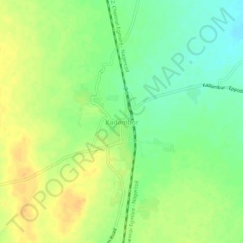
Name: Kadambur topographic map, elevation, terrain.
Location: Kadambur, Kovilpatti, Thoothukudi, Tamil Nadu, 627714, India (8.97973 77.84198 9.01973 77.88198)
Average elevation: 308 ft
Minimum elevation: 256 ft
Maximum elevation: 351 ft
Make a donation
Gear up for your next adventure:
As an Amazon Associate, this site earns from qualifying purchases at no extra cost to you.
Other topographic maps
Click on a map to view its topography, its elevation and its terrain.
Kovilpatti
India > Tamil Nadu > Kovilpatti
Kovilpatti is located at 9°10′N 77°52′E / 9.17°N 77.87°E / 9.17; 77.87. It has an average elevation of 101 metres (334 feet).
Average elevation: 318 ft
Kovilpatti
India > Tamil Nadu > Kovilpatti
Kovilpatti is located at 9°10′N 77°52′E / 9.17°N 77.87°E / 9.17; 77.87. It has an average elevation of 106 metres (347 feet). Located 100 km south of Madurai, 55 km north of Tirunelveli and 60 km north-west of Tuticorin, Kovilpatti is situated on National Highway No. 07 NH 7, which connects…
Average elevation: 318 ft
Kovilpatti
India > Tamil Nadu > Kovilpatti
Kovilpatti is located in South India. It has an average elevation of 101 meters (334 ft).
Average elevation: 318 ft
Kovilpatti
India > Tamil Nadu > Kovilpatti
Kovilpatti is located at 9°10′N 77°52′E / 9.17°N 77.87°E / 9.17; 77.87. It has an average elevation of 106 metres (347 feet). Located 100 km south of Madurai, 55 km north of Tirunelveli and 60 km north-west of Tuticorin, Kovilpatti is situated on National Highway No. 07 NH 7, which connects…
Average elevation: 318 ft
Make a donation
Gear up for your next adventure:
As an Amazon Associate, this site earns from qualifying purchases at no extra cost to you.