
Make a donation
Gear up for your next adventure:
As an Amazon Associate, this site earns from qualifying purchases at no extra cost to you.
Clifty Falls topographic map
Click on the map to display elevation.
Make a donation
Gear up for your next adventure:
As an Amazon Associate, this site earns from qualifying purchases at no extra cost to you.
About this map
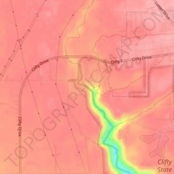
Name: Clifty Falls topographic map, elevation, terrain.
Location: Clifty Falls, Jefferson County, Indiana, United States (38.76640 -85.43629 38.76650 -85.43619)
Average elevation: 823 ft
Minimum elevation: 545 ft
Maximum elevation: 869 ft
Jefferson County trails, hiking, mountain biking, running and outdoor activities
Make a donation
Gear up for your next adventure:
As an Amazon Associate, this site earns from qualifying purchases at no extra cost to you.
Other topographic maps
Click on a map to view its topography, its elevation and its terrain.
Clifty Falls State Park
United States > Indiana > Jefferson County > Madison
Average elevation: 787 ft