
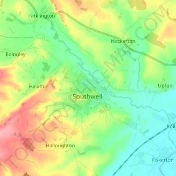
Southwell CP topographic map
Interactive map
Click on the map to display elevation.
About this map
Name: Southwell CP topographic map, elevation, terrain.
Average elevation: 154 ft
Minimum elevation: 39 ft
Maximum elevation: 354 ft
Other topographic maps
Click on a map to view its topography, its elevation and its terrain.
Staythorpe CP
United Kingdom > England > Nottinghamshire > Newark and Sherwood
Staythorpe CP, Newark and Sherwood, Nottinghamshire, England, United Kingdom
Average elevation: 52 ft
Newark on Trent
United Kingdom > England > Nottinghamshire > Newark and Sherwood
Newark on Trent, Newark and Sherwood, Nottinghamshire, England, NG24 1EJ, United Kingdom
Average elevation: 59 ft
Sherwood Forest NNR
United Kingdom > England > Nottinghamshire > Newark and Sherwood > Ollerton
Sherwood Forest NNR, Ollerton, Newark and Sherwood, Nottinghamshire, England, NG21 9HN, United Kingdom
Average elevation: 233 ft
Goverton
United Kingdom > England > Nottinghamshire > Newark and Sherwood > Bleasby
Goverton, Bleasby, Newark and Sherwood, Nottinghamshire, England, NG14 7FN, United Kingdom
Average elevation: 108 ft