
Niphad topographic map
Click on the map to display elevation.
Niphad
Niphad is the name both of the town and the Taluka headquartered there. It is within the Nashik District of Maharashtra, India. The Marathi name signifies "a place without mountains", and indeed the taluka's topography is fairly level, with hardly any hills. It is served by Niphad railway station. Niphad's latitude and longitude coordinates are 20°5′0″N 74°7′0″E / 20.08333°N 74.11667°E / 20.08333; 74.11667. Located northeast of Nashik city, the Taluka borders Sinnar, Nashik, Dindori, Chandwad, and Yeola Talukas and Ahmednagar District, and has no direct access to the sea. The Niphad Sub-Division is composed of Niphad, Sinnar and Yeola Talukas.
About this map
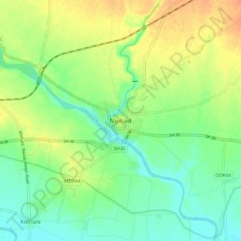
Name: Niphad topographic map, elevation, terrain.
Average elevation: 1,804 ft
Minimum elevation: 1,752 ft
Maximum elevation: 1,870 ft