
Rödermark topographic map
Click on the map to display elevation.
Rödermark
The town lies mostly in the Messeler Hügelland, a part of the Lower Main Plain with gentle hills. Differences in elevation are slight, reaching from about 130 m above sea level on the Rodau riverside flats east of Ober-Roden up to about 200 m above sea level on the Bulau. Rödermark is surrounded by greenbelts, found mainly in the area of the river Rodau. The Rodau crosses the municipal area from west to east. The northern areas of Bulau, Messenhausen and Waldacker have a mainly residential function, whereas the main centres of Ober-Roden and Urberach offer a complete infrastructure. The nearest Autobahn interchanges are ten kilometres away, and Frankfurt Airport some 25 km away. Rödermark lies within the area covered by the Rhein-Main-Verkehrsverbund, and on the grounds of Rödermark-Ober-Roden station’s favourable location, it is the terminus of Rhine-Main S-Bahn line S1 and a station on RMV line 61.
About this map
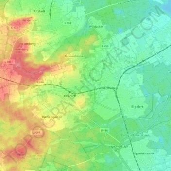
Name: Rödermark topographic map, elevation, terrain.
Location: Rödermark, Landkreis Offenbach, Hesse, 63322, Germany (49.94652 8.74135 50.00887 8.85354)
Average elevation: 512 ft
Minimum elevation: 404 ft
Maximum elevation: 682 ft