
Saarde küla topographic map
Interactive map
Click on the map to display elevation.
About this map
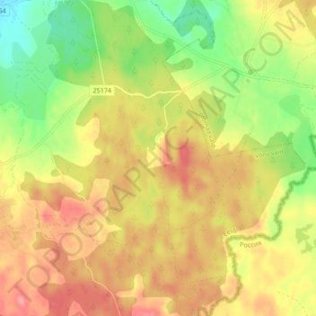
Name: Saarde küla topographic map, elevation, terrain.
Location: Saarde küla, Võru vald, Kreis Werro, 65239, Estland (57.67508 27.33188 57.71972 27.41050)
Average elevation: 594 ft
Minimum elevation: 449 ft
Maximum elevation: 712 ft
Other topographic maps
Click on a map to view its topography, its elevation and its terrain.
Suur Munamägi
Estland > Kreis Werro > Hahnhof
Der Suur Munamägi (dt. Großer Eierberg) im Haanja-Höhenzug ist mit 318 m Seehöhe die höchste Erhebung Estlands und zugleich des Baltikums. Der Berg liegt in der Region Võrumaa unweit des Dorfes Haanja im Südosten Estlands, in der Nähe der Grenzen zu Lettland und Russland. Die Landschaft im Bereich des…
Average elevation: 850 ft