
Make a donation
Gear up for your next adventure:
As an Amazon Associate, this site earns from qualifying purchases at no extra cost to you.
Le Rouvre topographic map
Click on the map to display elevation.
Make a donation
Gear up for your next adventure:
As an Amazon Associate, this site earns from qualifying purchases at no extra cost to you.
About this map
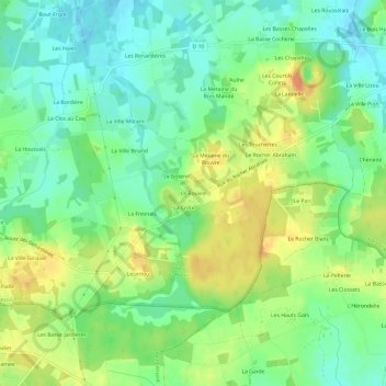
Name: Le Rouvre topographic map, elevation, terrain.
Average elevation: 223 ft
Minimum elevation: 164 ft
Maximum elevation: 302 ft
Make a donation
Gear up for your next adventure:
As an Amazon Associate, this site earns from qualifying purchases at no extra cost to you.
Other topographic maps
Click on a map to view its topography, its elevation and its terrain.
Lanhélin
France > Bretagne > Ille-et-Vilaine > Mesnil-Roc'h
Géomorphologiquement, Lanhélin est localisée dans le domaine nord armoricain (domaine qui se suit depuis la baie de Morlaix dans le Trégor jusqu'au Cotentin et se poursuit sous le bassin parisien), une des trois unités majeures du Massif armoricain, vieux socle granitique qui est le résultat de trois…
Average elevation: 213 ft
Make a donation
Gear up for your next adventure:
As an Amazon Associate, this site earns from qualifying purchases at no extra cost to you.
Lanhélin
France > Bretagne > Ille-et-Vilaine > Mesnil-Roc'h
Géomorphologiquement, Lanhélin est localisée dans le domaine nord armoricain (domaine qui se suit depuis la baie de Morlaix dans le Trégor jusqu'au Cotentin et se poursuit sous le Bassin parisien), une des trois unités majeures du Massif armoricain, vieux socle granitique qui est le résultat de trois…
Average elevation: 213 ft