
Delitzsch topographic map
Click on the map to display elevation.
Delitzsch
Delitzsch is located in the northwestern part of Nordsachsen in Saxony, at an altitude of 94 meters above sea level. Due to its location on the border with Saxony-Anhalt, Delitzsch is the northernmost town in Saxony. It is situated on the north heath and recreation area Goitzsche which extends across the Saxony-Saxony-Anhalt border to Bitterfeld-Wolfen. To the east is the spa town of Bad Düben, which is the starting point for the Düben Heath.
About this map
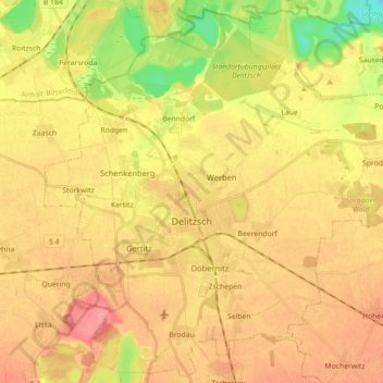
Name: Delitzsch topographic map, elevation, terrain.
Location: Delitzsch, Nordsachsen, Saxony, 04509, Germany (51.48097 12.27433 51.58696 12.45214)
Average elevation: 312 ft
Minimum elevation: 174 ft
Maximum elevation: 407 ft
Other topographic maps
Click on a map to view its topography, its elevation and its terrain.