
Gomesende topographic map
Interactive map
Click on the map to display elevation.
About this map
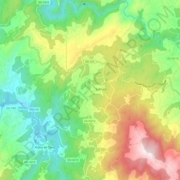
Name: Gomesende topographic map, elevation, terrain.
Location: Gomesende, Tierra de Celanova, Orense, Galicia, 32212, España (42.14670 -8.12680 42.23129 -8.06882)
Average elevation: 1,302 ft
Minimum elevation: 233 ft
Maximum elevation: 3,071 ft
Other topographic maps
Click on a map to view its topography, its elevation and its terrain.
Poulo
España > Galicia > Tierra de Celanova > Gomesende
Poulo, Gomesende, Tierra de Celanova, Orense, Galicia, España
Average elevation: 1,453 ft