
Lindbergh topographic map
Click on the map to display elevation.
About this map
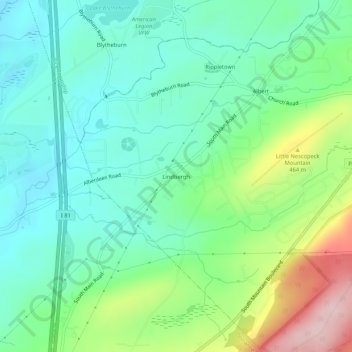
Name: Lindbergh topographic map, elevation, terrain.
Average elevation: 1,266 ft
Minimum elevation: 1,024 ft
Maximum elevation: 1,857 ft
Other topographic maps
Click on a map to view its topography, its elevation and its terrain.
Mountain Top
United States > Pennsylvania > Luzerne County > Wright Township
The elevation within the Mountain Top CDP ranges from 1,070 feet (330 m) above sea level along Big Wapwallopen Creek in the southwest, to 1,860 feet (570 m) atop Nescopeck Mountain southwest of Rita, to 1,871 feet (570 m) at the east end of Penobscot Mountain in the north of the CDP. The central village of…
Average elevation: 1,519 ft
Mountain Top
United States > Pennsylvania > Luzerne County > Wright Township
The elevation in Mountain Top ranges from 1,070 feet (330 m) above sea level along Big Wapwallopen Creek in the southwest, to 1,860 feet (570 m) atop Nescopeck Mountain southwest of Rita, to 1,871 feet (570 m) at the east end of Penobscot Mountain in north Mountain Top. The central village of Mountain Top sits…
Average elevation: 1,519 ft