Geolocate

Pasco topographic map

Click on the map to display elevation.

About this map

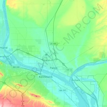
Name: Pasco topographic map, elevation, terrain.

Location: Pasco, Franklin County, Washington, United States (46.16084 -119.40044 46.37063 -119.02158)

Average elevation: 541 ft

Minimum elevation: 308 ft

Maximum elevation: 1,480 ft

Franklin County trails, hiking, mountain biking, running and outdoor activities

Gear up for your next adventure:

🧥Waterproof Jacket for Hiking - Breathable and rugged rain jacket for outdoor excursions
🥩Freeze-Dried Meals - Nutritious and lightweight food for remote expeditions
🎒Trekking Poles - Sturdy poles for balance and stability on rough terrain
🧭GPS Watch Accessories - Bands and chargers for GPS watches
🔌Solar Panel Charger - Charge gear sustainably outdoors

As an Amazon Associate, this site earns from qualifying purchases at no extra cost to you.