Geolocate

Lapa topographic map

Click on the map to display elevation.

About this map

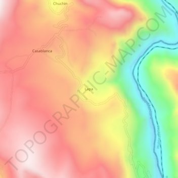
Name: Lapa topographic map, elevation, terrain.

Location: Lapa, Colca, Huancayo, Junín, Peru (-12.36558 -75.17038 -12.32558 -75.13038)

Average elevation: 11,312 ft

Minimum elevation: 9,806 ft

Maximum elevation: 12,349 ft

Gear up for your next adventure:

🛌Ultralight Sleeping Bags - Compact down bags for cold nights in the wilderness
🏫Relief Map Kits - Hands-on tools for teaching landforms and elevation
🧢Sun Protection Hats - Wide-brimmed and UPF-rated hats for high-altitude sun safety
🌄Hiking Binoculars - Compact binoculars for scenic views and trail spotting
🧥Men's Rain Shells - Premium waterproof and breathable jackets for mountain weather

As an Amazon Associate, this site earns from qualifying purchases at no extra cost to you.