
Thank you for supporting this site ❤️
Make a donation
Make a donation
Gear up for your next adventure:
As an Amazon Associate, this site earns from qualifying purchases at no extra cost to you.
Ermsdorf topographic map
Click on the map to display elevation.
Thank you for supporting this site ❤️
Make a donation
Make a donation
Gear up for your next adventure:
As an Amazon Associate, this site earns from qualifying purchases at no extra cost to you.
About this map
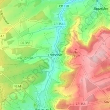
Name: Ermsdorf topographic map, elevation, terrain.
Location: Ermsdorf, Vallée de l'Ernz, Canton Diekirch, 9366, Luxembourg (49.80882 6.20140 49.84882 6.24140)
Average elevation: 1,056 ft
Minimum elevation: 751 ft
Maximum elevation: 1,417 ft
Thank you for supporting this site ❤️
Make a donation
Make a donation
Gear up for your next adventure:
As an Amazon Associate, this site earns from qualifying purchases at no extra cost to you.