Geolocate

Badami topographic map

Click on the map to display elevation.

Badami

Badami is located at 15°55′N 75°41′E / 15.92°N 75.68°E / 15.92; 75.68. It has an average elevation of 586 metres (1922 ft). It is located at the mouth of a ravine between two rocky hills and surrounds Agastya tirtha water reservoir on the three other sides. The total area of the town is 10.3 square kilometers.

About this map

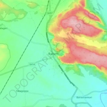
Name: Badami topographic map, elevation, terrain.

Location: Badami, Badami taluku, Bagalkote district, Karnataka, 587200, India (15.88039 75.64079 15.96039 75.72079)

Average elevation: 1,926 ft

Minimum elevation: 1,729 ft

Maximum elevation: 2,316 ft

Gear up for your next adventure:

Backpacking Tents - Weight-optimized shelters for multi-day topographic surveys
📡GPS Antenna Upgrade - Enhance GPS reception in remote terrain
👓Polarized Sunglasses - Outdoor sunglasses for glare reduction
🎒Day Hiking Backpack - Lightweight backpack perfect for day trips and outdoor adventures
🧭GPS Watch Accessories - Bands and chargers for GPS watches

As an Amazon Associate, this site earns from qualifying purchases at no extra cost to you.