
Make a donation
Gear up for your next adventure:
As an Amazon Associate, this site earns from qualifying purchases at no extra cost to you.
Kohlberg topographic map
Click on the map to display elevation.
Make a donation
Gear up for your next adventure:
As an Amazon Associate, this site earns from qualifying purchases at no extra cost to you.
Kohlberg
Der Kohlberg ist ein Berg der Iserlohner Höhe im märkischen Sauerland und stellt mit 514 m die höchste Erhebung der Stadt Neuenrade dar. Er bildet die natürliche Grenze zwischen Neuenrade und der Stadt Altena bzw. dem Ortsteil Dahle.
Make a donation
Gear up for your next adventure:
As an Amazon Associate, this site earns from qualifying purchases at no extra cost to you.
About this map
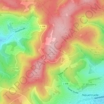
Name: Kohlberg topographic map, elevation, terrain.
Average elevation: 1,401 ft
Minimum elevation: 1,020 ft
Maximum elevation: 1,703 ft
Make a donation
Gear up for your next adventure:
As an Amazon Associate, this site earns from qualifying purchases at no extra cost to you.