
Thank you for supporting this site ❤️
Make a donation
Make a donation
Gear up for your next adventure:
As an Amazon Associate, this site earns from qualifying purchases at no extra cost to you.
Cocotitlán topographic map
Click on the map to display elevation.
Thank you for supporting this site ❤️
Make a donation
Make a donation
Gear up for your next adventure:
As an Amazon Associate, this site earns from qualifying purchases at no extra cost to you.
About this map
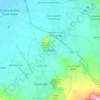
Name: Cocotitlán topographic map, elevation, terrain.
Location: Cocotitlán, Estado de México, 56680, México (19.19083 -98.90186 19.27083 -98.82186)
Average elevation: 7,474 ft
Minimum elevation: 7,320 ft
Maximum elevation: 8,297 ft
Thank you for supporting this site ❤️
Make a donation
Make a donation
Gear up for your next adventure:
As an Amazon Associate, this site earns from qualifying purchases at no extra cost to you.