Geolocate

James City topographic map

Click on the map to display elevation.

About this map

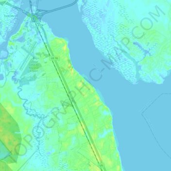
Name: James City topographic map, elevation, terrain.

Location: James City, Craven County, North Carolina, United States (35.00905 -77.05945 35.10277 -76.95509)

Average elevation: 13 ft

Minimum elevation: -23 ft

Maximum elevation: 59 ft

Craven County trails, hiking, mountain biking, running and outdoor activities

Other topographic maps

Click on a map to view its topography, its elevation and its terrain.

Lima

United States > North Carolina > Craven County

Average elevation: 13 ft

Croatan

United States > North Carolina > Craven County > Croatan

Average elevation: 33 ft

Clark

United States > North Carolina > Craven County

Average elevation: 23 ft

Gear up for your next adventure:

📱Solar Portable Charger - Solar power bank for charging devices off‑grid
🦟Ultrasonic Repellers - Create a bug-free zone at your camp or rest stop
🏕️Family Camping Gear - Essentials for group camping trips
🌡️Portable Weather Meter - Track weather conditions on the trail
🧼Biodegradable Camping Soap - Eco‑friendly soap for outdoor hygiene

As an Amazon Associate, this site earns from qualifying purchases at no extra cost to you.