Geolocate

Emerson topographic map

Click on the map to display elevation.

About this map

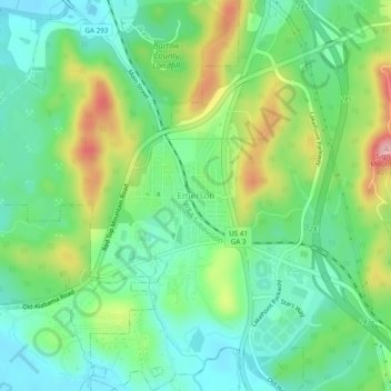
Name: Emerson topographic map, elevation, terrain.

Location: Emerson, Bartow County, Georgia, 30137, United States (34.10704 -84.77549 34.14704 -84.73549)

Average elevation: 873 ft

Minimum elevation: 676 ft

Maximum elevation: 1,270 ft

Bartow County trails, hiking, mountain biking, running and outdoor activities

Gear up for your next adventure:

📷Action Camera - Capture your outdoor adventures in HD
Backpacking Tents - Weight-optimized shelters for multi-day topographic surveys
🦶Carbon Trekking Poles - Reduce knee impact on steep descents with ultra-light poles
👓Polarized Sunglasses - Outdoor sunglasses for glare reduction
🧺Microfiber Travel Towels - Compact and fast-drying towels for trail use

As an Amazon Associate, this site earns from qualifying purchases at no extra cost to you.