
Jasper topographic map
Click on the map to display elevation.
About this map
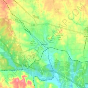
Name: Jasper topographic map, elevation, terrain.
Location: Jasper, Walker County, Alabama, 35501, United States (33.79122 -87.31751 33.87122 -87.23751)
Average elevation: 404 ft
Minimum elevation: 266 ft
Maximum elevation: 610 ft
Walker County trails, hiking, mountain biking, running and outdoor activities
Other topographic maps
Click on a map to view its topography, its elevation and its terrain.
Tanyard Creek
United States > Alabama > Walker County > Jasper > Frisco Quarters
Average elevation: 361 ft