
Municipal District of Greenview topographic map
Interactive map
Click on the map to display elevation.
About this map
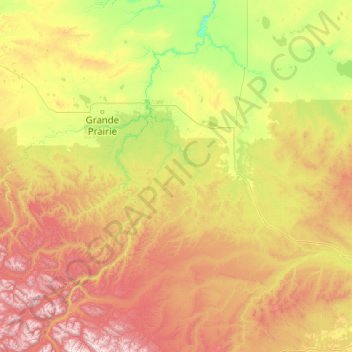
Name: Municipal District of Greenview topographic map, elevation, terrain.
Location: Municipal District of Greenview, Alberta, Canada (53.80181 -120.00137 55.68101 -115.96744)
Average elevation: 3,041 ft
Minimum elevation: 1,217 ft
Maximum elevation: 8,537 ft
Other topographic maps
Click on a map to view its topography, its elevation and its terrain.
Hamlet of Grande Cache
Canada > Alberta > Municipal District of Greenview
Hamlet of Grande Cache, Municipal District of Greenview, Alberta, T0E 0Y0, Canada
Average elevation: 3,786 ft