
Make a donation
Gear up for your next adventure:
As an Amazon Associate, this site earns from qualifying purchases at no extra cost to you.
Parc de Bercy topographic map
Click on the map to display elevation.
Make a donation
Gear up for your next adventure:
As an Amazon Associate, this site earns from qualifying purchases at no extra cost to you.
About this map
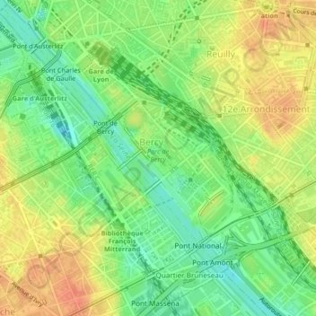
Name: Parc de Bercy topographic map, elevation, terrain.
Average elevation: 148 ft
Minimum elevation: 72 ft
Maximum elevation: 220 ft
Make a donation
Gear up for your next adventure:
As an Amazon Associate, this site earns from qualifying purchases at no extra cost to you.
Other topographic maps
Click on a map to view its topography, its elevation and its terrain.
Paris
France > Île-de-France > Paris
Paris présente une topographie relativement plate, avec une altitude moyenne d'environ 50 mètres au-dessus du niveau de la mer. Cependant, la ville est ponctuée de plusieurs collines notables qui modèlent son paysage urbain. La butte Montmartre, culminant à 131 mètres, est la plus élevée et offre une…
Average elevation: 203 ft
Paris 15e Arrondissement
France > Île-de-France > Paris
Le 15e arrondissement est une zone au relief peu marqué : il comprend le point le plus bas de Paris (28 m) et son altitude maximale ne dépasse pas une soixantaine de mètres.
Average elevation: 171 ft
Make a donation
Gear up for your next adventure:
As an Amazon Associate, this site earns from qualifying purchases at no extra cost to you.
Montagne Sainte-Geneviève
France > Île-de-France > Paris
Les constructions qui se sont succédé depuis environ 2 000 ans rendent difficile la recherche du point de vue géologique. Néanmoins on peut faire l’hypothèse suivante à partir des fouilles effectuées : les Romains ont construit la ville antique à partir d’un plan quadrillé dont l’origine était…
Average elevation: 167 ft
Make a donation
Gear up for your next adventure:
As an Amazon Associate, this site earns from qualifying purchases at no extra cost to you.
Make a donation
Gear up for your next adventure:
As an Amazon Associate, this site earns from qualifying purchases at no extra cost to you.
Make a donation
Gear up for your next adventure:
As an Amazon Associate, this site earns from qualifying purchases at no extra cost to you.
Grotte artificielle du parc des Buttes-Chaumont
France > Île-de-France > Paris
Average elevation: 246 ft
Make a donation
Gear up for your next adventure:
As an Amazon Associate, this site earns from qualifying purchases at no extra cost to you.
Make a donation
Gear up for your next adventure:
As an Amazon Associate, this site earns from qualifying purchases at no extra cost to you.
Montmartre
France > Île-de-France > Paris
L'altitude de Montmartre mesurée sur le trottoir à l'angle entre la clôture du 2, rue du Mont-Cenis et le bâtiment du 4 rue du Mont-Cenis est de 128,21 mètres. Le repère de nivellement no 70055, situé 2, rue du Mont-Cenis indique 128,163 mètres.
Average elevation: 207 ft
Make a donation
Gear up for your next adventure:
As an Amazon Associate, this site earns from qualifying purchases at no extra cost to you.
Make a donation
Gear up for your next adventure:
As an Amazon Associate, this site earns from qualifying purchases at no extra cost to you.
Make a donation
Gear up for your next adventure:
As an Amazon Associate, this site earns from qualifying purchases at no extra cost to you.
Make a donation
Gear up for your next adventure:
As an Amazon Associate, this site earns from qualifying purchases at no extra cost to you.
Make a donation
Gear up for your next adventure:
As an Amazon Associate, this site earns from qualifying purchases at no extra cost to you.
Make a donation
Gear up for your next adventure:
As an Amazon Associate, this site earns from qualifying purchases at no extra cost to you.
Make a donation
Gear up for your next adventure:
As an Amazon Associate, this site earns from qualifying purchases at no extra cost to you.
Make a donation
Gear up for your next adventure:
As an Amazon Associate, this site earns from qualifying purchases at no extra cost to you.
Make a donation
Gear up for your next adventure:
As an Amazon Associate, this site earns from qualifying purchases at no extra cost to you.
Paris
France > Île-de-France > Paris
Paris présente une topographie relativement plate, avec une altitude moyenne d'environ 50 mètres au-dessus du niveau de la mer. Cependant, la ville est ponctuée de plusieurs collines notables qui modèlent son paysage urbain. La butte Montmartre, culminant à 131 mètres, est la plus élevée et offre une…
Average elevation: 203 ft
Make a donation
Gear up for your next adventure:
As an Amazon Associate, this site earns from qualifying purchases at no extra cost to you.
Paris
France > Île-de-France > Paris
Paris présente une topographie relativement plate, avec une altitude moyenne d'environ 50 mètres au-dessus du niveau de la mer. Cependant, la ville est ponctuée de plusieurs collines notables qui modèlent son paysage urbain. La butte Montmartre, culminant à 131 mètres, est la plus élevée et offre une…
Average elevation: 194 ft
Paris
France > Île-de-France > Paris
Paris présente une topographie relativement plate, avec une altitude moyenne d'environ 50 mètres au-dessus du niveau de la mer. Cependant, la ville est ponctuée de plusieurs collines notables qui modèlent son paysage urbain. La butte Montmartre, culminant à 131 mètres, est la plus élevée et offre une…
Average elevation: 203 ft
Make a donation
Gear up for your next adventure:
As an Amazon Associate, this site earns from qualifying purchases at no extra cost to you.