Geolocate

Lympne topographic map

Interactive map

Click on the map to display elevation.

About this map

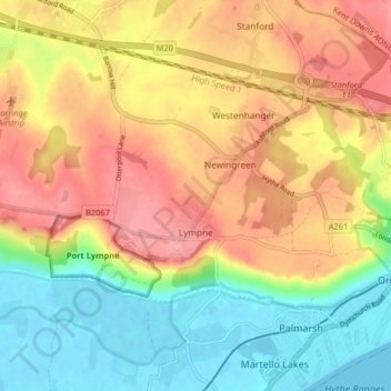
Name: Lympne topographic map, elevation, terrain.

Location: Lympne, Folkestone and Hythe District, Kent, England, United Kingdom (51.06661 0.96654 51.09453 1.04742)

Average elevation: 184 ft

Minimum elevation: -7 ft

Maximum elevation: 371 ft

Other topographic maps

Click on a map to view its topography, its elevation and its terrain.

Hythe

United Kingdom > England > Kent > Folkestone and Hythe District

Hythe, Folkestone and Hythe District, Kent, England, United Kingdom

Average elevation: 105 ft

Folkestone

United Kingdom > England > Kent > Folkestone and Hythe District

Folkestone, Folkestone and Hythe District, Kent, England, United Kingdom

Average elevation: 203 ft

Park Gate

United Kingdom > England > Kent > Folkestone and Hythe District > Elham

Park Gate, Elham, Folkestone and Hythe District, Kent, England, CT4 6BH, United Kingdom

Average elevation: 427 ft

Littlestone on Sea

United Kingdom > England > Kent > Folkestone and Hythe District > New Romney

Littlestone on Sea, New Romney, Folkestone and Hythe District, Kent, England, TN28 8QU, United Kingdom

Average elevation: 3 ft

Densole

United Kingdom > England > Kent > Folkestone and Hythe District

Densole, Folkestone and Hythe District, Kent, England, CT18 7BE, United Kingdom

Average elevation: 479 ft