
Make a donation
Gear up for your next adventure:
As an Amazon Associate, this site earns from qualifying purchases at no extra cost to you.
Bossòst topographic map
Click on the map to display elevation.
Make a donation
Gear up for your next adventure:
As an Amazon Associate, this site earns from qualifying purchases at no extra cost to you.
Bossòst
La municipalité s'étend sur les deux rives de la Garonne, mais le village de Bossòst est principalement implanté en rive gauche, à 712 mètres d'altitude. Située au pied du col du Portillon, qui la relie à Bagnères-de-Luchon, Bossòst est traversée par la route nationale N-230 qui relie Vielha à la France.
Make a donation
Gear up for your next adventure:
As an Amazon Associate, this site earns from qualifying purchases at no extra cost to you.
About this map
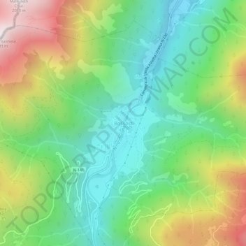
Name: Bossòst topographic map, elevation, terrain.
Location: Bossòst, Val-d'Aran, Lérida, Catalogne, 25550, Espagne (42.76599 0.67312 42.80599 0.71312)
Average elevation: 3,684 ft
Minimum elevation: 2,119 ft
Maximum elevation: 6,529 ft
Make a donation
Gear up for your next adventure:
As an Amazon Associate, this site earns from qualifying purchases at no extra cost to you.