Geolocate

Huron topographic map

Click on the map to display elevation.

About this map

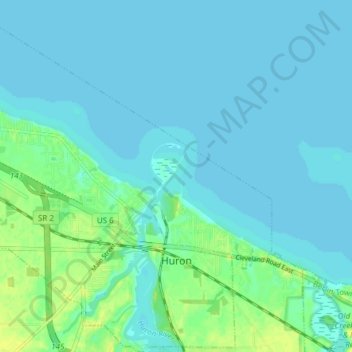
Name: Huron topographic map, elevation, terrain.

Location: Huron, Erie County, Ohio, 44839, United States (41.37229 -82.59340 41.42912 -82.52568)

Average elevation: 577 ft

Minimum elevation: 564 ft

Maximum elevation: 623 ft

Erie County trails, hiking, mountain biking, running and outdoor activities

Other topographic maps

Click on a map to view its topography, its elevation and its terrain.

Chaska Beach

United States > Ohio > Erie County > Huron

Average elevation: 581 ft

North Palm Beach

United States > Ohio > Erie County > Huron

Average elevation: 581 ft

Gear up for your next adventure:

🦺Reflective Outdoor Gear - Safety gear for low‑light conditions
🧤Hiking Gloves - Protective gloves for rugged trails
🧭Pro Hiking Compasses - High-accuracy liquid-filled compasses for topographic orientation
🧺Microfiber Travel Towels - Compact and fast-drying towels for trail use
🛡️Bear Spray Outdoor - Protection in bear country hikes

As an Amazon Associate, this site earns from qualifying purchases at no extra cost to you.