
Make a donation
Gear up for your next adventure:
As an Amazon Associate, this site earns from qualifying purchases at no extra cost to you.
Irvine topographic map
Click on the map to display elevation.
Make a donation
Gear up for your next adventure:
As an Amazon Associate, this site earns from qualifying purchases at no extra cost to you.
About this map
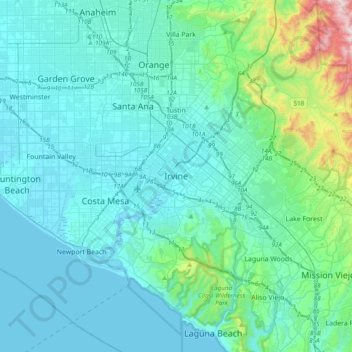
Name: Irvine topographic map, elevation, terrain.
Location: Irvine, Orange County, California, 92614, United States (33.52570 -117.98598 33.84570 -117.66598)
Average elevation: 367 ft
Minimum elevation: -10 ft
Maximum elevation: 2,999 ft
Orange County trails, hiking, mountain biking, running and outdoor activities
Make a donation
Gear up for your next adventure:
As an Amazon Associate, this site earns from qualifying purchases at no extra cost to you.
Other topographic maps
Click on a map to view its topography, its elevation and its terrain.
Orange County Great Park
United States > California > Orange County > Irvine
Average elevation: 282 ft
Orange County Great Park
United States > California > Orange County > Irvine
Average elevation: 381 ft
Make a donation
Gear up for your next adventure:
As an Amazon Associate, this site earns from qualifying purchases at no extra cost to you.