
Make a donation
Gear up for your next adventure:
As an Amazon Associate, this site earns from qualifying purchases at no extra cost to you.
Villavicencio topographic map
Click on the map to display elevation.
Make a donation
Gear up for your next adventure:
As an Amazon Associate, this site earns from qualifying purchases at no extra cost to you.
Villavicencio
Topográficamente se distinguen dos regiones: una montañosa ubicada al occidente y noroccidente, formada por el costado de la Cordillera Oriental; la otra, una planicie inclinada ligeramente hacia el oriente y el nororiente, corresponde al piedemonte de la cordillera, bordeada al norte por el río Guatiquía. En la parte central de esta planicie cruzan los ríos Ocoa y Negro, además de numerosos caños y afluentes menores. En el noroccidente se encuentra el P.N.N Chingaza con sus alrededores de El Calvario y San Juanito, al occidente del departamento se encuentra el P.N.N Sumapaz con cercanía a Bogotá.
Make a donation
Gear up for your next adventure:
As an Amazon Associate, this site earns from qualifying purchases at no extra cost to you.
About this map
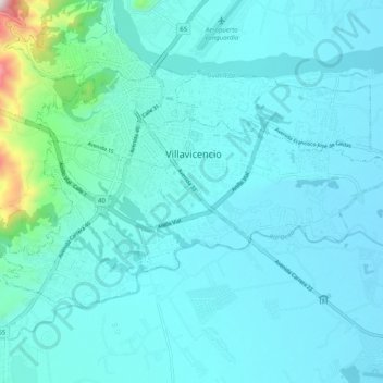
Name: Villavicencio topographic map, elevation, terrain.
Location: Villavicencio, Meta, Colombia (4.09132 -73.66544 4.15864 -73.56511)
Average elevation: 1,480 ft
Minimum elevation: 1,204 ft
Maximum elevation: 3,858 ft
Make a donation
Gear up for your next adventure:
As an Amazon Associate, this site earns from qualifying purchases at no extra cost to you.
Other topographic maps
Click on a map to view its topography, its elevation and its terrain.
Make a donation
Gear up for your next adventure:
As an Amazon Associate, this site earns from qualifying purchases at no extra cost to you.