
Make a donation
Gear up for your next adventure:
As an Amazon Associate, this site earns from qualifying purchases at no extra cost to you.
Bellegem topographic map
Click on the map to display elevation.
Make a donation
Gear up for your next adventure:
As an Amazon Associate, this site earns from qualifying purchases at no extra cost to you.
Bellegem
Bellegem ligt op een heuvelrug in Zandlemig Vlaanderen. De hoogte van de kern bedraagt 65 meter (Sint-Leonardusberg) en de hoogte van de deelgemeente varieert van 23 tot 73 meter. Enkele kleinere beken zoals Kortrijkbeek, Ooievaarsnestbeek en Kwademeersbeek. Natuurgebieden zijn het Bellegembos en Argendaalbos.
Make a donation
Gear up for your next adventure:
As an Amazon Associate, this site earns from qualifying purchases at no extra cost to you.
About this map
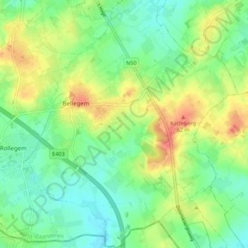
Name: Bellegem topographic map, elevation, terrain.
Location: Bellegem, Kortrijk, West-Vlaanderen, Vlaanderen, België (50.74937 3.26543 50.79795 3.33014)
Average elevation: 128 ft
Minimum elevation: 52 ft
Maximum elevation: 243 ft
Make a donation
Gear up for your next adventure:
As an Amazon Associate, this site earns from qualifying purchases at no extra cost to you.
Other topographic maps
Click on a map to view its topography, its elevation and its terrain.
Kortrijk
België > West-Vlaanderen > Kortrijk > Kortrijk
Het bewind van Filips de Stoute, hertog van Bourgondië, luidde een periode van vrede en heropbouw in die zeventig jaar duurde. Een nieuw kasteel werd opgetrokken ter hoogte van de Kasteelkaai en Kasteelstraat. Nieuwe stadsmuren met een Broeltoren aan de noordkant integreerden de bestaande toren in de…
Average elevation: 79 ft
Make a donation
Gear up for your next adventure:
As an Amazon Associate, this site earns from qualifying purchases at no extra cost to you.