Geolocate

Trier topographic map

Click on the map to display elevation.

About this map
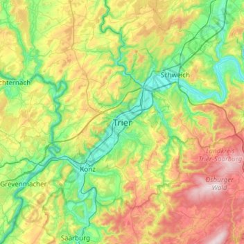
Name: Trier topographic map, elevation, terrain.

Location: Trier, Rhineland-Palatinate, 54290, Germany (49.59962 6.48419 49.91962 6.80419)

Average elevation: 1,030 ft

Minimum elevation: 367 ft

Maximum elevation: 2,336 ft

Gear up for your next adventure:

🌡️Portable Weather Meter - Track weather conditions on the trail
📌Outdoor GPS Map App - Apps and devices for digital topographic navigation
🚑Emergency Bivvies - Heat-reflective sleeping bags for survival situations
🩳Quick‑Dry Hiking Shorts - Comfortable and quick‑dry shorts for summer hiking
🧷Carabiner Set - Durable clips for gear attachment

As an Amazon Associate, this site earns from qualifying purchases at no extra cost to you.