
Make a donation
Gear up for your next adventure:
As an Amazon Associate, this site earns from qualifying purchases at no extra cost to you.
Cañon City topographic map
Click on the map to display elevation.
Make a donation
Gear up for your next adventure:
As an Amazon Associate, this site earns from qualifying purchases at no extra cost to you.
Cañon City
Cañon City is located in eastern Fremont County at 38°26′48″N 105°13′42″W / 38.44667°N 105.22833°W / 38.44667; -105.22833 (38.446800, -105.228305) at an altitude of 5,332 feet (1,625 m). It sits primarily on the north side of the Arkansas River, just east of where the river exits from Royal Gorge. It is bordered to the south by the unincorporated community of Lincoln Park. Via U.S. Route 50, Pueblo is 39 miles (63 km) to the east and Poncha Springs is 62 miles (100 km) to the west. Colorado Springs is 45 miles (72 km) to the northeast.
Make a donation
Gear up for your next adventure:
As an Amazon Associate, this site earns from qualifying purchases at no extra cost to you.
About this map
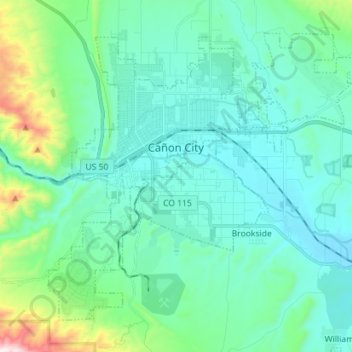
Name: Cañon City topographic map, elevation, terrain.
Location: Cañon City, Fremont County, Colorado, 81212, United States (38.38784 -105.27392 38.47835 -105.13228)
Average elevation: 5,653 ft
Minimum elevation: 5,190 ft
Maximum elevation: 7,887 ft
Fremont County trails, hiking, mountain biking, running and outdoor activities
Make a donation
Gear up for your next adventure:
As an Amazon Associate, this site earns from qualifying purchases at no extra cost to you.
Other topographic maps
Click on a map to view its topography, its elevation and its terrain.
Make a donation
Gear up for your next adventure:
As an Amazon Associate, this site earns from qualifying purchases at no extra cost to you.
Make a donation
Gear up for your next adventure:
As an Amazon Associate, this site earns from qualifying purchases at no extra cost to you.