Geolocate

Mauban topographic map

Click on the map to display elevation.

About this map

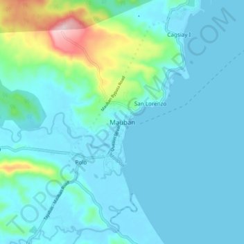
Name: Mauban topographic map, elevation, terrain.

Location: Mauban, Quezon, Calabarzon, 4330, Philippines (14.15005 121.69147 14.23005 121.77147)

Average elevation: 141 ft

Minimum elevation: -13 ft

Maximum elevation: 1,001 ft

Other topographic maps

Click on a map to view its topography, its elevation and its terrain.

Guinayangan

Philippines > Quezon

Average elevation: 223 ft

Talipan

Philippines > Quezon > Pagbilao

Average elevation: 184 ft

Tagkawayan

Philippines > Quezon

Average elevation: 351 ft

Alabat Island

Philippines > Quezon

Average elevation: 36 ft

Pagbilao Grande Island

Philippines > Quezon > Pagbilao

Average elevation: 43 ft

Dolores

Philippines > Quezon

Average elevation: 994 ft

Mauban

Philippines > Quezon

Average elevation: 515 ft

San Antonio

Philippines > Quezon

Average elevation: 463 ft

Dumacaa River

Philippines > Quezon > Lucena

Average elevation: 26 ft

Dalawang Islands

Philippines > Quezon > Polillo

Average elevation: 3 ft

Pulong Pasig Sandbar

Philippines > Quezon > Santo Angel

Average elevation: 0 ft

Malaking Tubig River

Philippines > Quezon > Lucena

Average elevation: 79 ft

Jomalig

Philippines > Quezon

Average elevation: 3 ft

Gear up for your next adventure:

🩹Survival Bandages - High‑quality bandages for emergencies
🧭Hiking Compass - Precision compass for reliable navigation in the wilderness
🧦Merino Wool Socks - Moisture-wicking, blister-preventing socks for long treks
🧤Tactile Hiking Gloves - Keep hands warm while operating GPS and smartphone screens
🎒Outdoor Daypacks - Lightweight backpacks designed for carrying maps and essential gear

As an Amazon Associate, this site earns from qualifying purchases at no extra cost to you.