
Bedwell Harbour topographic map
Interactive map
Click on the map to display elevation.
About this map
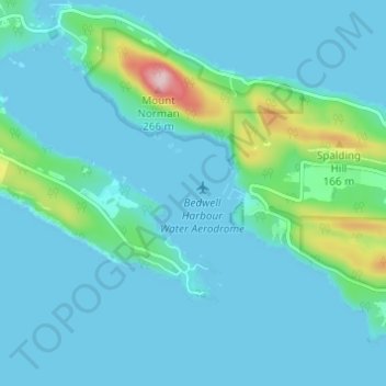
Name: Bedwell Harbour topographic map, elevation, terrain.
Average elevation: 98 ft
Minimum elevation: -3 ft
Maximum elevation: 758 ft
Other topographic maps
Click on a map to view its topography, its elevation and its terrain.
South Pender Island
Canada > British Columbia > Southern Gulf Islands Electoral Area
South Pender Island, Southern Gulf Islands Electoral Area, Capital Regional District, British Columbia, Canada
Average elevation: 89 ft
Retreat Island
Canada > British Columbia > Southern Gulf Islands Electoral Area
Retreat Island, Southern Gulf Islands Electoral Area, Capital Regional District, British Columbia, Canada
Average elevation: 115 ft
Moresby Island
Canada > British Columbia > Southern Gulf Islands Electoral Area
Moresby Island, Southern Gulf Islands Electoral Area, Capital Regional District, British Columbia, Canada
Average elevation: 62 ft
Mowgli Island
Canada > British Columbia > Southern Gulf Islands Electoral Area
Mowgli Island, Southern Gulf Islands Electoral Area, Capital Regional District, British Columbia, V0R 2Y0, Canada
Average elevation: 10 ft
Mount Warburton Pike
Canada > British Columbia > Southern Gulf Islands Electoral Area
Mount Warburton Pike, Southern Gulf Islands Electoral Area, Capital Regional District, British Columbia, V0N 2Y0, Canada
Average elevation: 584 ft