
Make a donation
Gear up for your next adventure:
As an Amazon Associate, this site earns from qualifying purchases at no extra cost to you.
Elvas topographic map
Click on the map to display elevation.
Make a donation
Gear up for your next adventure:
As an Amazon Associate, this site earns from qualifying purchases at no extra cost to you.
Elvas
Assim, o clima, de feição mediterrânico, apresenta aqui uma secura estival acentuada e um Outono e Inverno pluviosos, obviamente, não tão pluviosos como em certas regiões do país, de superior altitude ou mais próximas da influência oceânica.
Make a donation
Gear up for your next adventure:
As an Amazon Associate, this site earns from qualifying purchases at no extra cost to you.
About this map
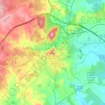
Name: Elvas topographic map, elevation, terrain.
Average elevation: 902 ft
Minimum elevation: 591 ft
Maximum elevation: 1,348 ft
Make a donation
Gear up for your next adventure:
As an Amazon Associate, this site earns from qualifying purchases at no extra cost to you.