
Thank you for supporting this site ❤️
Make a donation
Make a donation
Gear up for your next adventure:
As an Amazon Associate, this site earns from qualifying purchases at no extra cost to you.
Otley topographic map
Click on the map to display elevation.
Thank you for supporting this site ❤️
Make a donation
Make a donation
Gear up for your next adventure:
As an Amazon Associate, this site earns from qualifying purchases at no extra cost to you.
About this map
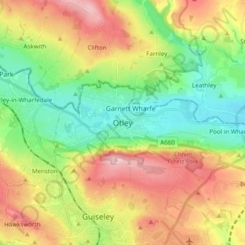
Name: Otley topographic map, elevation, terrain.
Location: Otley, Yorkshire and the Humber, England, LS21, United Kingdom (53.86551 -1.73389 53.94551 -1.65389)
Average elevation: 463 ft
Minimum elevation: 138 ft
Maximum elevation: 922 ft
Thank you for supporting this site ❤️
Make a donation
Make a donation
Gear up for your next adventure:
As an Amazon Associate, this site earns from qualifying purchases at no extra cost to you.